Important note: The following is entirely fictional.
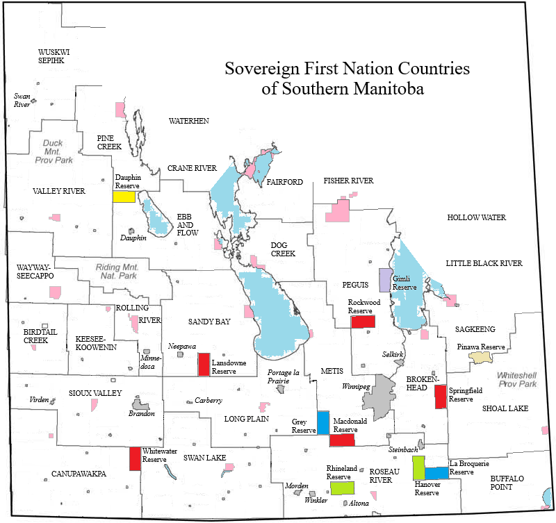
The map above shows the result of the territorial changes accompanying the creation of the Federated First Nation Province of Manitoba. Here is a brief description of these changes.
The entire area of the Province of Manitoba is ceded to the First Nations peoples that reside in it, except for the two following types of territorial units:
- All urban municipalities (i.e. cities, towns and villages) – these are colored grey on the map
- A certain number of non-First Nation reserves to be created in certain rural areas – see below for colors used on the map
All rural municipalities as well as all unorganized areas are partitioned between the many different First Nations bands. In the case of the rural municipalities, they are all effectively annexed by the already-existing First Nation reserves. For example:
- Roseau River Anishinabe First Nation annexes the rural municipalities of Stuartburn, Franklin-Emerson, Montcalm, Rhineland, Stanley, Dufferin, Thompson, Roland, Morris, De Salaberry, Hanover and La Broquerie.
- Brokenhead Ojibway Nation annexes the rural municipalities of St. Clements, Brokenhead, Springfield, Tache and Ste. Anne.
- Peguis First Nation annexes the rural municipalities of Fisher, Bifrost, Armstrong, Gimli, Rockwood and St. Andrews.
- The following rural municipalities are assigned to the Metis Nation: Coldwell, St. Laurent, Woodlands, Rosser, St. Francois Xavier, Carter, Headingley, Macdonald and Ritchot.
The rural municipalities of East St. Paul and West St. Paul are annexed by the City of Winnipeg.
The original areas of the main First Nations reserves are shown in pink on the map.
The greatly expanded First Nations territories are officially denoted as countries (e.g. Roseau River Country, Peguis Country, Metis Country, Canupawakpa Country).
The non-First Nation reserves generally consist of two townships each (2 X 36 = 72 square miles) and include the following:
- Five Anglo-Canadian reserves detached from Springfield RM, Macdonald RM, Rockwood RM, Glenella-Lansdowne RM (former Lansdowne portion) and Grasslands RM (former Whitewater portion) – these are colored in red on the map
- Two French-Canadian reserves detached from La Broquerie RM and Grey RM – these are colored in blue on the map
- Two Mennonite reserves detached from Hanover RM and Rhineland RM – these are colored in green on the map
- One Ukrainian reserve detached from Dauphin RM – this is colored in yellow on the map
- One Icelandic reserve detached from Gimli RM & Bifrost RM – this is colored in lavender on the map
- One Vindonian reserve consisting of the area of the former Local Government District of Pinawa – this is colored in beige on the map
